-

by
Joe Lombardi
Weather
A complex storm system accompanying a strong cold front could bring up to 4 inches of rainfall to parts of the Northeast leading to a new threat of flash flooding.Ahead of the arrival of the system, it will be dry on Thursday, Oct. 5, with skies gradually becoming sunny after morning fog, according to the National Weather Service. The high temperature will be in the low to ...
-

by
Ben Crnic
Breaking News
With heavy rain pummeling much of New York and causing flash flooding concerns, Gov. Kathy Hochul is updating residents on the planned emergency response to the downpours. As a precautionary measure in response to the barrage of rain, flood rescue teams will be staged in Westchester and Nassau Counties by the New York Division of Homeland Security and Emergency Services in case they are ...
-

by
Jerry DeMarco & Cecilia Levine
Breaking News
Heavy rain on Friday, Sept. 29 closed major roadways across New Jersey.Gov. Phil Murphy declared a State of Emergency in the late afternoon, as rain continued falling, leaving drivers trapped in flood waters across the state.Dunderhook Road at Paramus Road in Paramus remained closed due to flooding, leading the borough's Office of Emergency Management to urge an evacuation of the area ...
-

by
Joe Lombardi
Weather
A dangerous coastal storm is bringing flooding downpours to much of the Northeast, with the New York City tristate area, Long Island, Hudson Valley and southern New England most at risk.In those areas, heavy rainfall is likely with the potential of scattered to numerous areas of flash flooding during the day Friday, Sept. 29, into Friday night, according to the National Weather ...
-

by
Ben Crnic
Breaking News
As forecasts call for a long stretch of heavy rainfall, New York Gov. Kathy Hochul is warning residents to prepare for potential flash flooding.The warning comes as forecasters predict heavy downpours in the Hudson Valley, New York City, and Long Island regions beginning on Thursday night, Sept. 28, and lasting through Friday night, Sept. 29, which may bring as much as five inches of ...
-
by
Joe Lombardi
Weather
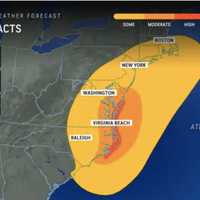
A newly named tropical storm that has formed off the coast of North Carolina will bring heavy rain that could cause flooding along with strong wind gusts to much of the Northeast this weekend.New update - Tropical Storm Ophelia Makes Landfall, Moves North, Will Bring Heavy Rain, Strong Winds To RegionTropical Storm Ophelia is packed with winds of about 60 miles per hour and was about ...
-

by
Ben Crnic
Weather
With Hurricane Lee barreling on a path toward the Northeast, meteorologists have now identified the areas of Massachusetts that may face the most devastation and power outages from storm surges and damaging winds. According to the latest information from the National Weather Service, the storm is expected to arrive in southern New England on Friday night, Sept. 15, and stay through ...
-

by
Joe Lombardi
Weather
More potentially severe scattered thunderstorms are once again expected to sweep through the region for the second half of the weekend after previous activity resulted in downed trees and thousands of power outages the previous three days.The next window for storm activity is in the afternoon and evening on Sunday, Sept. 10. "Slow-moving showers and thunderstorms along a stalled frontal ...
-

by
Joe Lombardi
Weather
More potentially severe scattered thunderstorms are expected to sweep through the region this weekend after previous activity resulted in downed trees and thousands of power outages the previous two days.The next window for storm activity is in the afternoon and evening on Saturday, Sept. 9. The main threat will be damaging winds, with additional threats for isolated large hail and ...
-

by
Joe Lombardi
Weather
New rounds of potentially severe scattered thunderstorms will sweep through as an unsettled weather pattern has arrived in the region.The next window for storm activity is in the afternoon and evening on Friday, Sept. 8.The main threat will be damaging winds, with additional threats for isolated large hail and flash flooding, according to the National Weather Service.Hot and humid ...
-

by
Joe Lombardi
Weather
Localized flash flooding is possible as a cold front with heavy downpours and embedded thunderstorms moves through the region.For a look at a radar image of the region at about 7:30 a.m. Friday, Aug. 25, see the first image above.Friday will be mostly cloudy and humid throughout the day with a high temperature in the mid-70s. There will be showers and spotty storms during the morning ...
-

by
Zak Failla
Weather
Just as the region cleaned up from last week's rash of thunderstorms, a new batch of severe weather is heading toward the region.Whipping winds approaching 70 mph are possible along with a chance of a tornado, hail, and flash flooding potentially hitting some parts of Washington, DC, Maryland, and Virginia on Monday, Aug. 14, forecasters are advising.Hot and humid air paired with an ...


