-

by
Joe Lombardi
Weather
An offshore storm could take a tropical turn, giving East Coast communities another reason to watch the forecast closely.The National Hurricane Center's outlook gives the system a 40 percent chance of developing within seven days, but a near-zero chance within 48 hours.The non-tropical low sits a few hundred miles off the southeastern US coast. It could acquire subtropical ...
-

by
Zak Failla
Weather
Some severe weather is expected in DC, Maryland, and Virginia as storms approach the region, bringing potential hail and possibly even a tornado, forecasters warn.An alert was issued by the National Weather Service on Monday, March 31 advising that there is a risk in the DMV region for severe thunderstorms after an unseasonably warm day.Forecasters said that the primary risk is damaging ...
-

by
Joe Lombardi
National Interest
A massive storm that now pushing off the East Coast has left a trail of destruction, mainly in the South and Midwest, with 40 fatalities now reported.As of 8:15 a.m. on Monday, March 17, the system is generating widespread rainfall and thunderstorms as a strong cold front advances. (See the radar image above.)A total of 52 tornadoes have been reported, with more possible, alongside ...
-
by
Cecilia Levine
Weather
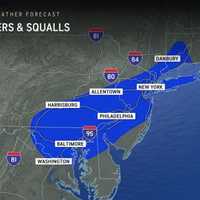
A storm system moving in brings the potential for snow squalls, 55 mph winds, and frigid temps mid-week in New Jersey and Pennsylvania, forecasters have said in a new update.⚠️❄️🌬️ Not much change to the forecast for tonight through Thursday. Some snow showers may result in some light...Posted by US National Weather Service Philadelphia/Mount Holly on Wednesday, December 4, 2024A ...
-
by
Cecilia Levine
Weather
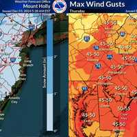
A powerful cold front is set to move through the region mid-week, bringing light snow and widespread gusts of 40-50 mph, with higher totals in some areas, according to the National Weather Service (NWS).The storm is expected to bring rain and snow showers starting Wednesday night, Dec. 4, with minor snowfall accumulations possible through Thursday morning. Most areas in New Jersey will ...
-
by
Zak Failla
Weather
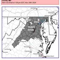
Forecasters are cautioning that some wild weather may be moving through the DMV region through the weekend as the area braces for possible snow storms in parts of the area.A "Special Weather Statement" was issued by the National Weather Service advising that wind gusts possibly approaching 50 mph may be on the way on Wednesday night, bringing with it a strong cold front and possibly a ...
-
by
Cecilia Levine
Weather
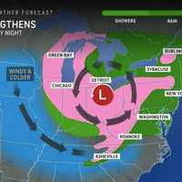
Cooler temperatures are here to stay for the week, with the National Weather Service forecasting rain and even snow in some parts of New Jersey this week (scroll for snow map).The National Weather Service in Mount Holly says that the cold front, which brought a 5- to 10-degree temperature drop, will continue to influence the region's weather. "Widespread rain, and even a little snow in ...
-
by
Cecilia Levine
Weather
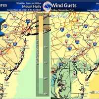
A cold front will end the summer-like warmth in the Northeast — for now, forecasters say."For the next seven to 10 days at least, warm days will outnumber chilly ones, relative to the historical average," AccuWeather Senior Meteorologist Brett Anderson said. "This means that when all the days are tallied up, temperatures will be several degrees above that historical average, which is ...
-
by
Cecilia Levine
National Interest
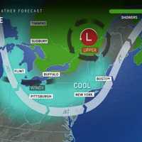
Break out those jean jackets. After a day of rain, temps are expected to drop for a classic fall day in the Northeast, forecasters say.Saturday, Sept. 7 will be rainy with a high of 75 and showers on the lighter side with the exception of a few thunderstorms, according to the National Weather Service. AccuWeather says the rain will fall during the first part of the weekend.Unsettled ...
-

by
Cecilia Levine
Weather
Thousands of New Jersey residents woke up Monday morning, Aug. 19 without power due to Sunday's storm.And according to the National Weather Service, more stormy weather could be on the way for later in the day.As of 6:40 a.m., JCP&L was reporting the most outages with the following areas without power: Clinton, 880; Branchville, 150; Hopatcong, 215; Long Branch/Asbury Park, 350; ...
-

by
Joe Lombardi & Cecilia Levine
Weather
We're going out with a bang.The final day of heat and humidity in New Jersey and Pennsylvania is expected to precede a brand-new round of strong to severe thunderstorms ahead of the arrival of a cold front, the National Weather Service says.Storm activity on Sunday, June 23, will last from around 2 p.m. until around 11 p.m., with the most severe storms expected starting in the late ...
-

by
Zak Failla
Weather
Whipping winds are likely, and there is a remote possibility of severe weather in parts of the DMV region on Wednesday heading into Thursday, forecasters are cautioning.Some rain and gusty wind were expected on Feb. 28, as officials say a cold front is coming to the area with winds sitting at around 25 mph and gusts expected later on Wednesday reaching upwards of 55 mph before settling ...
-
by
Chris Spiker
Weather
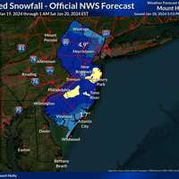
After several storms brought rain, wind, and wintry weather to the Jersey Shore to start 2024, cities and towns are bracing for what could be the heaviest snowfall along the coast so far this winter.Parts of South Jersey could see up to six inches of snow on Friday, Jan. 18 — the highest amounts predicted across all of the the Garden State, according to the National Weather Service. ...
-
by
Cecilia Levine
Weather
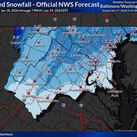
The National Weather Service has released a brand-new map showing projected snow totals coming to the mid-Atlantic later this week.Wednesday, Jan. 17 is expected to be "very cold" with temps struggling to reach the freezing mark southeast of Washington DC in the afternoon, the NWS said. Sunny skies are expected today, but it will remain very cold.Posted by US National Weather Service ...
-

by
Zak Failla
Weather
Another storm may bring upwards of an inch of snow to parts of Maryland, Virginia, and DC on Sunday, according to forecasters.While the DMV region won't face the same perils that forced the NFL to postpone the Buffalo Bills playoff game in upstate New York, some parts of the area may see a wintry mix on Jan. 14 as they celebrate the holiday weekend.Temperatures began cooling down on ...
-

by
Cecilia Levine
Weather
Several inches of snow could fall across parts of Pennsylvania in a powerful storm headed to the region this weekend.While the weekend will begin with a warmup with temps expected to reach 59 come Sunday, Dec. 10, a cold front isn't far behind.By Sunday night, temps will hit a low of 33. Rain and thunderstorms that will have begun in the morning will turn to snow in the northernmost ...
-

by
Joe Lombardi
Weather
A complex storm system accompanying a strong cold front could bring up to 4 inches of rainfall to parts of the Northeast leading to a new threat of flash flooding.Ahead of the arrival of the system, it will be dry on Thursday, Oct. 5, with skies gradually becoming sunny after morning fog, according to the National Weather Service. The high temperature will be in the low to ...
-

by
Joe Lombardi
Weather
Showers and thunderstorms will sweep through the region ahead of an approaching cold front.Higher levels of humidity levels will help to ignite the storms Friday, Aug. 4.Storm activity is possible starting around midday before becoming likely late in the afternoon and in the evening.Rain will be heavy at times with some drenching downpours.About an inch to 1.5 inches of rainfall is ...
-

by
Joe Lombardi
Weather
Dangerous extreme heat from the Midwest will start to spread East, with the first heat wave of the summer set to scorch the region.A heat wave is defined as three straight days in which the high temperature hits 90 degrees or above.High temperatures on Wednesday, July 26 will generally be in the upper 80s to around the 90-degree mark with hazy sunshine most of the day, the National ...
-

by
Joe Lombardi
Weather
Scattered thunderstorms, some severe, are moving across the region ahead of a strong cold front.Some of the storms, which began in the middle of the afternoon Friday, June 2, have been packed with heavy downpours, and gusty winds.Since the backdoor front is moving from east to west (rather than the usual west to east), storm are moving from the northeast in an easterly fashion.The ...
-

by
Joe Lombardi
Weather
A cold front will move through the region accompanied by precipitation and followed by a drop in temperatures.Ahead of the late-day arrival of the front on Wednesday, May 24, skies will be mainly clear, according to the National Weather Service. The high temperature will be in the mid-70s.A line of showers will accompany the front, with a slight chance of thunderstorms, late Wednesday ...
-

by
Joe Lombardi
Weather
A showery, foggy start to the week will be followed by a shift to cooler temperatures with breezy conditions.Monday, April 17 has started off with morning showers and areas of dense fog. It will gradually become mostly sunny later in the afternoon as a cold front approaches. The high temperature will be in the mid to upper 60s. For a look at the high temperatures on Monday from the ...
-

by
Joe Lombardi
Weather
An unsettled weather pattern that has arrived in the region will include scattered thunderstorms and dramatic shifts in temperatures.Morning fog on Thursday, April 6 will give way to partial sunshine with a line of showers and isolated thunderstorms moving in for the afternoon and evening, according to the National Weather Service. Parts of our area have been upgraded to a slight risk ...
-

by
Joe Lombardi
Weather
Get set for a spring break ahead of a new storm system that will sweep through the region.Temperatures will climb in the upper 50s and low 60s on Wednesday, Feb. 15, and Thursday, Feb. 16 under cloudy skies both days before a new storm system arrives Thursday afternoon into Friday, Feb. 17, according to the National Weather Service."It will be warm enough that many people will be able ...
-

by
Joe Lombardi
Breaking News
The most dangerous wind gusts that accompanied a cold front moving through the region have passed, but more than 1,000 remain without power on Long Island.As of around 9:15 a.m. Saturday, Feb. 4, PSEG Long Island is reporting a total of 1,186 affected customers, with an overwhelming amount in Suffolk.Here's the breakdown of outages by county:Suffolk, 946Nassau, 240Related story: ...
-

by
Joe Lombardi
Breaking News
The most dangerous wind gusts that accompanied a cold front that is moving through the region have passed, but thousands remain without power in Connecticut.As of around 9 a.m. Saturday, Feb. 4, Eversource is reporting around 3,500 outages statewide, with United Illuminating reporting around 55 outages in its service territory.These municipalities are reporting the most ...
-

by
Michael Mashburn
Breaking News
More than a thousand customers are without power as strong winds pummel Long Island early Friday evening, Feb. 3. As of 5:45 p.m., there were 1,560 customers in the dark across Nassau and Suffolk counties, according to PSEG Long Island’s outage map. Earlier Report: Damaging Wind Gusts Could Cause Power Outages As 'Extremely Dangerous' Arctic Blast ArrivesThe outages come as a powerful ...
-

by
Ben Crnic
Breaking News
As a powerful cold front brings heavy winds and freezing Arctic air to the Hudson Valley, thousands of customers have been left without power from fallen trees and power lines. The front arrived on Friday, Feb. 3, also bringing a blast of cold Arctic air that along with the damaging wind gusts, is making temperatures feel below-freezing at times.Related story - Damaging Wind Gusts Could ...
-

by
Ben Crnic
Breaking News
Heavy wind gusts from a powerful cold front traveling through the Northeast are causing thousands of people to lose power throughout Westchester County. The cold front, arriving in the area on Friday, Feb. 3, is bringing gusts as strong as 35 miles per hour to the region, along with Arctic air. The combination of the chilled air and wind will make it feel below-freezing at times, ...
-

by
Joe Lombardi
Weather
Let's hope Santa Claus is wearing an extra pair or two of long johns.That's because Christmas Eve and Christmas Day will be the coldest in decades.A powerful, massive storm that brought a mix of heavy rain, damaging winds, sleet, and snow, has now moved off the coast, but the passage of a cold front accompanying the system has led to a dramatic dip in temperatures.The wind-chill factor ...
-
by
Joe Lombardi
Weather
Let's hope Santa Claus is wearing an extra pair -- or two -- of long johns.That's because Christmas Eve and Christmas Day will be the coldest in decades.A powerful, massive storm that brought a mix of heavy rain, damaging winds, sleet, and snow, has now moved off the coast, but the passage of a cold front accompanying the system has led to a dramatic dip in temperatures.The wind-chill ...


